CAMUSS 2016 – The program is now online!
You are cordially invited to participate in the Second International Symposium on Cellular Automata Modeling for Urban and Spatial Systems (CAMUSS 2016) that will be held in a beautiful UNESCO World Heritage Site, Quebec City, Canada from September 21st to 23rd, 2016. The Symposium will provide you with an excellent opportunity to meet and exchange [...]
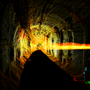
MinEyes: Development and optimization of mobile LiDAR technologies for the precise 3D modeling and monitoring of mining tunnels convergence
A team of researchers, composed of Mir Abolfazl Mostafavi (director of the Convergence Network), Josée Dallaire (Director of the Centre de géomatique du Québec and member of the Convergence Network), Christian Larouche, Martin Grenon, Jacek Paraszczak and Kamran Esmaeili, just obtained a grant for the project “MinEyes: Development and optimization of mobile LiDAR technologies for [...]
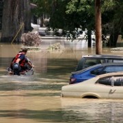
INRS develops a new flood risk analysis and management tool
Professors Karem Chokmani and Monique Bernier of INRS’s Eau Terre Environment Centre (and members of the Coonvergence Network) is developing GARI, a new flood risk analysis and management tool. The tool, a geographical information system (GIS) application, will consist of operational cartography and characterization modules for visualizing and analyzing flood risk in preparatory and operational [...]

Sylvie Daniel mentioned in a Contact Université Laval file about games
The Université Laval’s Communications Direction presents a file about games in general and video games in particular. Among the proposed articles, “L’art du jeu vidéo” talks about the work of Sylvie Daniel, member of the Convergence Network, where she explains how geomatics can contribute to the realism of video games. See the complete file Incursion [...]

Open Source Geospatial Research & Education 2016 – Call for short papers
The OGRS’16 organizing committee is pleased to announce the opening of the Call for short papers for inclusion in the program of the next edition of the Open Source Geospatial Research & Education Symposium (12-14 October 2016, Perugia, Italy). The deadline for the submission of short papers (1000-1500 words) is June 15th, 2016. All the [...]
CAMUSS 2016 – Call for Papers
The Convergence Network is organizing CAMUSS 2016 (Second International Symposium on Cellular Automata Modeling for Urban and Spatial Systems), in collaboration with the Center for Research in Geomatics and the Centre for Urban Policy Studies of the Université of Manchester. You are invited to submit a paper to this international event that will be held [...]